Cawdor: Placemaking Priority

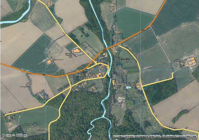
Figure 1: Map 49 Cawdor, Inner Moray Firth Local Development Plan 2, page 350, published for consultation 25th March 2023.

Cawdor is identified in the Inner Moray Firth Local Development Plan 2 as a Growing Settlement. It is addressed at Placemaking Priorities 39. Future development of Cawdor is embraced where this achieves small scale infill and rounding off, and of redevelopment of brownfield sites with no heritage value. Considerations and limitations are to avoid areas at risk of flooding from the Cawdor Burn, whilst preserving and enhancing woodland and watercourses whilst delivering and enhancing active travel use, connections, and biodiversity including the A96 Landward Trail. Reference Placemaking Priorities 30 Cawdor, Inner Moray Firth Local Development Plan 2, page 350, published for consultation 25th March 2023.

What would you like to see for a future Cawdor? Is sensitive infill and rounding out development what you see for a sustainable, green, Cawdor?

Perhaps you would like to see a more ambitious plan for Cawdor, where jobs and homes are created to retain skills and young families in the area?

Maybe you feel that an area of land around Cawdor should be protected and developed as a re-wilding, fostering woodlands of historic types and the natural environment, reducing flood risk and increasing biodiversity around the settlement?

However you see the future of Cawdor, we would love to see your plans to help create a comprehensive Nairnshire Local Place Plan. You can contact us at lpp@nicenairn.org.uk or by leaving your comments below.

Croy CR02: North West of Primary School

Figure 1: Map 12, Inner Moray Firth Local Development Plan 2, page 129, published for consultation 25th March 2023.

The area of land identified in CR02 is 6.4ha or thereby, and allocated for Housing, Community, and Business with an indicative capacity of 50 housing units. Reference CR02: North West of Primary School, Inner Moray Firth Local Development Plan 2, page 130, published for consultation 25th March 2023.

This area to the North West of the Primary School is obligated to ensure that there is no adverse effect on Loch Flemington, whilst giving consideration to transport, road networks, and the potential of creating a community and/or small scale commercial space.

How would you envisage this corner of Croy being developed to the best benefit of the community? Would you continue with a housing theme, mixed with a wooded edge to soften the town boundary, with a path network to link to Loch Flemington, the school, and the village centre?

Do you see a focus on a commercial and community hub, with housing dispersed around this central focus on creating employment, a sustainable local community, and a drive for a digital economy facing the wider global network?

Maybe you think this area should be sensitively developed with minimal intervention to create a re-wilded corner of Croy, with accessible path networks to bring people and nature together in a sustainable and harmonious space?

However you would do it, we need to know to ensure your Local Place Plan is the foundation stone for the future development of Nairnshire. You can contact us at lpp@nicenairn.org.uk, or leave your comments below.

Croy CR01: West of Primary School

Figure 1: Map 12 Croy, Inner Moray Firth Local Development Plan 2, page 129, published for consultation 25th March 2023.

The land allocation CR01: West of Primary School is allocated for housing, over an area circa 5.1ha and with an indicative housing capacity of 50 units. Full planning permission has previously been granted, 17/02509/FUL. Reference CR01: West of Primary School, Inner Moray Firth Local Development Plan 2, published for consultation 25th March 2023.

This area of land is generally under construction, sited below the new Milne Avenue access and speed limits on the B9006.

What impacts has the development of CR01 had for you and for Croy? What more needs to be done to ensure that Croy continues to develop and grow in a sustainable, green, and resilient way? Has CR01 added to, or reduced, the quality of your green network and active travel path network to Nairn and Nairnshire, or into Inverness or the Dalcross commercial and industrial areas?

We would love to know what you think, either directly at lpp@nicenairn.org.uk, or leaving your comment below.

Nairn NA07: Sawmill Expansion

Figure 1: Map 31, Inner Moray Firth Local Development Plan 2, page 278, issued for consultation 25th March 2023

Nairn NA07: Sawmill Expansion is an industrial zone, comprising 4.8ha or thereby to fully accommodate expansion of the Sawmill. Reference NA07: Sawmill Expansion, Inner Moray Firth Local Development Plan 2, page 283, published for consultation 25th March 2023.

Creating this enlarged area for the Sawmill Expansion safeguards and ensures sustainable employment in Nairnshire for the long term. The development of the site does require the assessment of impact upon the road network, and on supporting an “enhancement of active travel connections to the town centre”. Reference NA07: Sawmill Expansion, Inner Moray Firth Local Development Plan 2, page 283, published 25th March 2023.

Would you do it differently? If so, we would love to hear your thoughts and plans at lpp@nicenairn.org.uk or leave your comment below.

Nairn NA06: East of the Retail Park

Figure 1: Map 31, Inner Moray Firth Local Development Plan 2, page 278, published for consultation 25th March 2023

This site is bound by and, without development of NA05, accessed from the A96. The site has a total area of circa 2.1ha and is identified for a capacity of 40 new houses within a mixed use development of Housing, Business, and Community. Any development proposal should be presented as a Developer Masterplan prior to commencing any application. Reference NA06: East of the Retail Park, Inner Moray Firth Development Plan 2, page 282, published for consultation 25th March 2023.

The IMFLDP2 context to this site is set against one of potential archeological interest, which adds an interesting dynamic. It is also framed by the existing A96 footpath linking Nairn to Auldearn, which should be upgraded along the site frontage, ie alongside the A96.

How do you see the development opportunity for this area to the East of the Retail Park? as the potential corner stone to Nairn’s East arrival, with the first access of the A96, how would you aim to develop the site? Perhaps there is an opportunity to re-route the footpath away from the A96, to embrace an Active Travel green network upgrade between Nairn and Auldearn, whilst developing a unique affordable development, bringing housing within a few minutes walk of Balmakeith Industrial Estate?

Maybe you see the site as having the potential to create more employment, forming a small office and digital park, with an interesting green space fostering inside outside work spaces where nature and commerce can live side by side.

Perhaps you think the site is best suited to expanding the Retail Park, with additional retail units set within a striking wooded boundary, bringing additional jobs to Nairn?

Whatever your vision is, we would love to see it so that we can grow the Nairnshire Local Place Plan as fully as possible, helping to shape the future of Nairnshire as we all want it to be. You can contact us directly at lpp@nicenairn.org.uk or leave your comment below.

Nairn NA05: Nairn East

Figure 1: Map 31, Inner Moray Firth Local Development Plan 2, page 278, published for consultation 25th March 2023

Nairn East represents the largest single land allocation in Nairnshire, covering 98.3ha or thereby, over a mixed use development of Housing, Business, Community, and Industry with potential for 250 (650-850 Total) new houses.

Lying generally between the A96 to the North and the A939 to the South West, the development area creates the new gateway to Nairn from the East and the South. The developer shall submit a Development Brief ahead of any statutory pre-application submission, which shall include for an Engagement Strategy.

What would make the most of this significant area of land to the East end of Nairn? How would you engage any development here with Active Travel and green networks into the Town Centre, towards the Community Amenities of the schools and healthcare and onwards to the beach and leisure spaces? Can this be achieved whilst loading the A939 junction, and the main connection onto Granny Barbour’s Road with the potential of hundreds, if not more than 1,000 cars trying to move around during the day?

Perhaps you see the development at Nairn East differently, creating a small scale circular economy, with homes, business, and industry closely married to foster a 20 minute town within an enlarged Househill. With a strong green network, residents may be at work in minutes, take lunch from the local shop or café, use a Househill nursery and enjoy that their older children have a clear pathway to Nairn Academy?

Or maybe you see the opportunity here to focus on supporting the Grigorhill businesses to have the opportunity to grow into a new employment centre, creating sustainable, long term employment with training opportunity to retain and support Nairnshire’s young families to stay in Nairnshire? By investing in technology, in a digital connection, Grigorhill perhaps becomes your the Highland’s green tech hub for the next wave of technology?

However you see it, we want to know all about it. You can contact us directly at lpp@nicenairn.org.uk or leave your comment below.

Nairn NA04: Sandown

Figure 1: Map 31, Inner Moray Firth Local Development Plan 2, page 278, published for consultation 25th March 2023.

Land allocation NA04: Sandown represents a significant land area of 36.3ha. The site is identified as a mixed use development, including Housing, Business, and Community with an indicative capacity of 150 new houses (350 total). The site development should be in accordance with the Sandown Development Brief whilst developing:

  • a positive contribution to the A96 and entrance to Nairn, with a lights controlled pedestrian crossing;
  • Active Travel routes alongside the A96;
  • a Recreation Access Management Plan, which raises the potential impact of water based activities; and
  • provision and or contribution towards open space, path and green network requirements including mitigation associated with the Inverness to Nairn Coastal Trail

How would you assess a potential Sandown development? Does developing Sandown foster a 20 minute town, whilst creating affordable and accessible homes for growing employment in Nairnshire?

Perhaps your vision for Sandown is a mixed use West gateway to Nairn, making a show case for what could be achieved on the East gateway, bringing sustainable employment together with increased Community Amenities and carefully designed residential areas to foster the green network, accessing all that Nairn has to offer through Altonburn Road whilst creating a true sense of space?

Maybe you are happy with the Inner Moray Firth Local Development Plan 2 proposal, but would see another set of lights on the A96 as adding further pollution to static, congested traffic being stopped again and would rather that there is a by-pass in place before such a sizeable development adjacent to the A96, and that any pedestrian route should avoid conflict with the A96 howsoever and needs an over- or under-pass?

Or your concept for Sandown is simply to create an enhanced green space, fostering Active Travel, Community Amenity, and a space for people and nature to mix in a community owned natural environment conservation area?

Whatever your thoughts are, we would love to hear them directly at lpp@nicenairn.org.uk or leave your comments below.

Nairn NA03: Nairn Town Centre

Figure 1: Map 31, Inner Moray Firth Local Development Plan 2, page 278, published for consultation on 25th March 2023

Nairn’s town centre is identified as having potential development opportunity across mixed uses: housing; business; retail; and community. Potential for 20 new houses is identified over an area of 4.6. Reference Inner Moray Firth Local Development Plan 2, page 280.

The Inner Moray Firth Local Development Plan 2 identifies the Town Centre development area as the area between the A96 and the High Street, framed to the North by St Ninian Road (A96) and to the South by Leopold Street, and extending to include the Fire Station and bus station as far as this ground bounds onto Viewfield.

Is this how you view the Town Centre? Do you think the High Street experience should extend down Harbour Street to the harbour shops, café and restaurant, and encompass the remaining commercial activity here? Perhaps the High Street experience needs to extend to the harbour to aid mobility through the town, from the train station to the beach?

Can the Town Centre be enhanced to foster Active Travel within a Green, Resilient Nairn whilst attracting and promoting employment and business growth?

We would love to know what you think to best support Nairnshire’s Local Place Plan. You can contact us directly at lpp@nicenairn.org.uk or leave your comment below.

Nairn NA02: Former Showfield East

Figure 1. Nairn, Inner Moray Firth Local Development Plan 2, published for consultation 25th March 2023, page 278

Area NA02 Former Showfield East is identified in IMFLDP2 for an indicative 20 new homes in circa 0.8ha. Development of the site does feature requirements, including retaining the “green space, including provision of reconfigured sports pitch of at least equivalent size and quality”, all with enhanced parking and access provision. Reference Inner Moray Firth Local Development Plan 2, published for consultation 25th March 2023, page 279.

What do you think?

Is it possible to achieve an enhanced access, with parking, where access is generally obtained from Lodgehill Road?

How does an additional 20 homes, at an additional 30 vehicles (calculated using the THC planning formula of 1.5 cars per new home), feature accessing the A96 at one of the most congested stretches of the A96 as it travels through Nairn?

Perhaps you think this infill site makes clear sense in the sustainable development of Nairn, creating capacity increase in housing without expanding the boundaries of the town?

Or do you think that the Showfield represents a key Getting Around anchor point in accessing the primary schools and High Street from Achareidh and Tradespark, taking pedestrians and non-vehicular transport away from the A96 whilst maintaining green space and capacity for sports in the town centre?

You can tell us what you think directly at lpp@nicenairn.org.uk or leave your comment below.

Nairn NA01: Achareidh

Figure 1. Map 31 Nairn, Inner Moray Firth Local Development Plan, page 278, published for consultation 25th March 2023.

Area NA01 in Achareidh is identified for housing over an area of circa 18.4ha. The site is identified with an indicative capacity of 30 new houses.

How would you see the future of Achareidh?

Is 30 new houses a potential an increase in capacity for affordable homes, securing opportunity for Nairnshire’s young families to live and work in Nairn?

Perhaps you see the future of Achareidh as a corner stone in a green resilient Nairnshire, building on in-town green space and allotment farming, or perhaps you see the site as an extension of Community Amenities with development potential for an activity space in Nairn centre?

We’d love to receive your thoughts directly at lpp@nicenairn.org.uk, or leave a comment below.